- Sections
- Introduction
- Section 1: Getting started
- Section 2: Accessing Census data
- Section 3: Calculating the impact on districts
- Section 4: Repairing your democracy, now and in the future
- Tools
- Correctional Facility Locator (2020)
- Correctional Facility Locator (2010)
- Correctional Facility Locator (2000)
- Vote dilution calculator
- 2020 Worksheet [DOC] a single worksheet updated for use after the 2020 Census to determine if a county included or excluded the incarcerated population.
- Worksheets [DOC] with all of the tables used in this toolkit
- Appendices
- Handling lettered blocks
- Determining whether prisoners were included or excluded from districts with known populations.
- District population deviations & split prisons
- Weighted Voting
Section 2.
Accessing the data
In this section, you will find out where the Census counted prisons in your county. You will locate them according to Census block, and in the next section, you will find out what district each census block is in. This will help you determine what districts prisoners were credited to.
Step 1. Locate the prisons in the Census data.
Because the Census has not always identified prisons at their actual locations, we urge researchers to use our tool instead of their practical knowledge of prison locations. The Census altered the locations of some prisons by a few feet, but others were placed in the wrong town or county. While we know of only a handful of cases where these errors were corrected prior to redistricting, you will need to understand these errors in order to determine which districts are affected by the inclusion of prisoners as local population.
Almost all local governments use Census data to draw legislative district boundaries. You may know where the prisons are in your county, but you will need to know where the Census Bureau counted them. Because you are tracking the impact of Census data, it does not matter where the correctional facilities are in your county, it matters only where the Census Bureau thinks they are.
The Census Bureau has divided the United States into more than 8 million blocks and published each block's population. Legislators connect adjoining blocks to create districts with approximately equal populations. According to White v. Regester, 422 U.S. 935 (1975), state legislative districts must be the same size, with a maximum deviation of 5% from the ideal size. This is sometimes called the 10% rule, because it allows a 10% total deviation: one district may be 5% too large, and another 5% too small. While the U.S. Supreme Court has also required county legislative districts to contain approximately equal numbers of people, it has not established a maximum deviation for country districts. However, many jurisdictions believe that the 10% rule also applies to local districts.
We've built a tool, the Correctional Facility Locator, which lists the Census blocks with correctional facilities and helps you understand where these blocks are. The Census Bureau categorizes state prisons, federal prison, private prisons, local jails, military prisons and halfway houses as correctional facilities. To measure distortion in your county's democracy, you will be only interested in the larger facilities, which primarily house people from outside your county. Local jails are frequently small, and the prisoners are generally residents of your county, who are allowed to vote. Though they can harm representation the way larger facilities do, the impact of local jails is generally quite small.
For example, someone in St. Lawrence County, New York can enter that county's name in the Correctional Facility Locator and see that there are four Census blocks in St. Lawrence with correctional facilities. We've manually labeled three as state prisons, and one as a local jail.
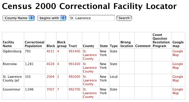
Screenshot of the search results for St. Lawrence County, New York
The Census Bureau doesn't label blocks with the facilities' names or types (state, federal, etc.). Most of the correctional facility blocks in the Locator are not yet labeled, so you will need to identify each one based on our lists of the populations of state, federal and local prisons and jails. (These lists are available in the "Resources on prison and jail populations" section at the bottom of the locator.) By process of elimination, you should be able to label each block in your county with a correctional population. We'll explain this process in more detail after we explain how the Correctional Facility Locator works.
The Correctional Facility Locator provides the following pieces of data:
- Facility Name
- If we have manually identified the correctional facility or facilities in this Census block, we've labeled it here.
- Correctional Population
- This is the number of people reported as being incarcerated in this Census block.
- Block
- Blocks are the smallest units of Census geography and are assigned numbers. The link goes to a Census map of the block.
- Block group
- Block groups are collections of Census blocks and are also assigned numbers. The link goes to a Census map of the block group.
- Tract
- Census tracts are small, relatively permanent statistical subdivisions of a county, delineated by local committees of census data users for the purpose of presenting data. Census tract boundaries normally follow visible features, but may follow governmental unit boundaries and other non-visible features. Designed to be relatively homogeneous in population characteristics, economic status, and living conditions at the time of establishment, census tracts average about 4,000 inhabitants. Each tract in a county has an identifying number. The link goes to a Census map of the tract.
- County
- States are divided in to counties or county-equivalents. The link goes to a Census map of the county.
- State
- The state that the census block is in.
- Type
- If we have manually identified the correctional facility by type, we have labeled it here. We have found that the Census Bureau's labels, provided in Summary File 1, Table PCT16, are so error-prone as to be unreliable. If your analysis requires you to remove local facilities and halfway houses, you will need to identify the facilities manually.
- Wrong location
- If we know that the Census Bureau placed a facility in the wrong location, we have noted it here.
- Comment
- Any other notes from our manual research are reported here.
- Count Question Resolution Program
- If the block is mentioned in the Census Bureau's Count Question Resolution Program, we report the corrected group quarters population and provide a link to the full data report.
- Google map
- This link shows a Google map of the location, including the satellite view. The marker reflects the center point of the block, but the prison itself may be some distance from this center point.
Your eventual goal will be to determine which blocks contain state and federal prisons, what population the Census Bureau counted there, and what legislative district contains the census blocks.
Here's how to use the data provided in each column for our example, St. Lawrence County.
Usually, you won't have the name of the facility or its type, just its reported location and population. If you click on the "Block" link for Ogdensburg, you will see a Census map of that block. (Warning: the first time you run our application per day, you may get the error "No map is available for the selected geography" because of a problem on the Census Bureau website, so just click on our link to the map again.) The block will be shaded in yellow. The default Census Bureau maps are not interactive, and can be confusing. If the map does not give you enough context to understand exactly where this is in your county, the blockgroup map will give you a larger view. The tract map will offer even more context.
Tip: Sometimes the tract maps are more useful if you know that the first digit of a block number is its block group. So block 9009 would be in blockgroup 9.
Tip: You might find it easier to use the Google map link. This will show you a map with a marker at the center of the block. While the Google maps are interactive and easier to read, be warned that Census map data can be several hundred feet off from the Google maps and that we were able to mark only the center of the block that contains the prison. When the Census Block is very large, this can be confusing, as in this Google map below shows a prison wedged between a golf course and an Air Force runway:
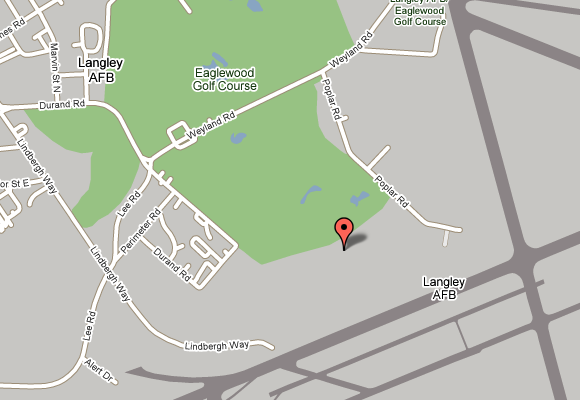
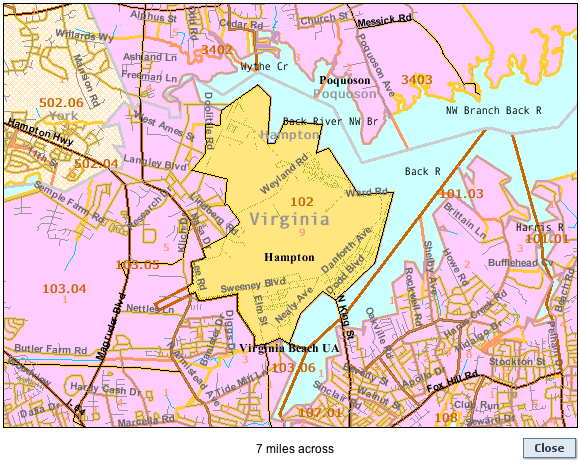
The actual block, however, as shown below, is very large and consists of the golf course, the runway and an entire Air Force Base:
Tip: Remember that you do not need to determine exactly where in the Census block the facility is in, only what census block the facility is in, what kind of facility it is, and, later, what district that block is in.
Step 2. What to do about prisons that were placed in the wrong spot
The Census Bureau counted many prisons in the wrong place and, rarely, counted the wrong number of people at the facility. The Census Bureau acknowledged some of these errors and a handful of jurisdictions corrected their data prior to redistricting. This step will guide you through the implications of these errors.
While the results of Census 2000 remain official, the Census Bureau has published the results of its Count Question Resolution program, which investigated many errors of omission, duplication, and "geocoding errors," in which people were reported in the wrong location. The CQR program only investigated complaints filed before September 30, 2003, so it is an incomplete list. Because of the difficulty in spotting these errors, the short timetable for redistricting, and the fact that the originally released data remained official, only a handful of its corrections were used in redistricting. Later, you may need to ask your county if they used any of these corrections, but understanding the Count Question Resolution data will also help you in the next step when you have to identify and label each correctional facility.
If any of the correctional blocks in your county are mentioned in the Count Question Resolution program, you will see a link and a note about whether the corrected population is higher or lower. If you follow the link, you will see a table with some data for your county. (To make things easier, we have included only the portion of the Count Question Resolution program that have a corrected group quarters population. This tool will therefore not be useful for listing Count Question Resolutions for households.)
Many users of this manual will not need to worry about this issue. If all three of these statements are true, you can skip ahead to Step 3: Labeling facilities by type. Otherwise, continue through this step.
- The CQR line is blank for all blocks reported in the locator for your county.
- The "Wrong location" line is blank for all blocks in your county.
- You did not discover any evidence that a prison was counted in the wrong spot. (If you discover evidence that a prison is in the wrong location but this is not reflected in the Count Question Resolution program, it is unlikely that county officials were aware of this when drawing the legislative districts. You can ask them, and if they corrected the data, you can make appropriate corrections in the next section.)
If you follow a link to Count Question Resolution program data for a block in your county, you will see new some data columns:
- Geography
- This is the name of the block, tract, town or county.
- County
- This is the name of the location's county.
- Census Tract
- Census tracts are small, relatively permanent statistical subdivisions of a county, delineated by local committees of census data users for the purpose of presenting data. Census tract boundaries normally follow visible features, but may follow governmental unit boundaries and other non-visible features. Designed to be relatively homogeneous in population characteristics, economic status, and living conditions at the time of establishment, census tracts average about 4,000 inhabitants. Each tract in a county has an identifying number. The link goes to a Census map of the tract.
- Census Block
- Blocks are the smallest units of Census geography and are assigned numbers. The link goes to a Census map of the block.
- Correctional population Census 2000
- This is the number of people reported as being incarcerated in this Census block. Unfortunately, the Count Question Resolution program does not provide corrected counts for correctional populations, only for the larger "group quarters" category.
- Group quarters 2000
- This is the population reported in Census 2000 as having lived in "group quarters," which include prisons, college dorms, military bases and some hospitals.
- Group quarters CQR
- This is the corrected count of the total group quarters population for this area. None of these corrections are reflected in any other official Census 2000 publication.
- Adjustment in Group Quarters count
- This is the difference between the Census 2000 count of the group quarters population and the corrected count published in the Count Question Resolution program.
Here is an example of the Count Question Resolution Program screen for Wyoming County, New York:
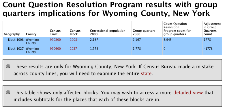
This is a screenshot of the Count Question Resolution results for Wyoming County. There are only two rows for this county. The second line shows that our Block 1027 in Tract 990600 lost 1,778 group quarters residents. The line above it, for Block 1008 in Tract 990200, was just adjusted upwards by the same figure of 1,778 group quarters residents. We can therefore conclude that the facility placed in Tract 990200, Block 1008, should be in Tract 990600, Block 1027. The Count Question Resolution program screen will have many more rows in some counties, and this may take some time.
Understanding the location of the correctional population is helpful for the next step: identifying which correctional populations are state or federal prisoners and which are local jails and other populations that will not affect your analysis.
Note that the Census Bureau did not publish corrected counts for correctional facilities. Instead, they published the original Census 2000 count of correctional facilities, the original Census 2000 count of people in group quarters (which includes correctional facilities, military barracks, college dorms, etc.) and the corrected count. You may have to look carefully and use the process of elimination. If our system thinks it can identify the block with the corrected population, it will highlight both the original block and the new block in blue.
Once you know where the Census Bureau has located the prison, you should look at the Census maps to determine where that block is. (In our example, we are looking for Block 1008.) This may help you with the identification and labeling process discussed in the next step.
Residents in these 11 counties will face a somewhat more complicated situation, because the Census Bureau changed the underlying blocks:
- Chatham County, Georgia
- Boone County, Missouri
- Pike County, Missouri
- Caldwell County, North Carolina
- Davie County, North Carolina
- Johnston County, North Carolina
- Wilson County, North Carolina
- McCormick County, South Carolina
- Claiborne County, Tennessee
- Wise County, Texas
- Chittenden County, Vermont
If you are working in one of these counties, see Handling lettered blocks.
By the end of Step 2, you will know how many people are in correctional facilities in each block in your county, and you will know where the Census Bureau believes those correctional populations are. In the next step you will identify each correctional facility by type in order to determine which are the state and federal prisons relevant to your analysis.
Step 3. Labeling facilities by type
Once you have a sense of where the Census Bureau counted facilities, you can identify each one by type. The end goal of this section is to identify the state and federal prisons, because these types of facilities are the largest and almost exclusively contain people who are residents of other parts of the state or country. You want to be able to identify exactly which populations your county legislature should have removed from the data before redistricting.
Example: The Census Bureau should have not counted the 56 people incarcerated in the Franklin County, NY Jail as if they were residents of the facility on Fort Covington Road in Malone, but they are at least residents of the county. Because county jails tend to be small, the impact on democracy is negligible. The only exception would be with regional jails, where a number of counties send their jail inmates to one facility. The New York City Jail on Rikers Island is one example of a jail so large that it makes sense to treat it for redistricting purposes as a prison filled with people from somewhere else.
You will want to exclude local jails and halfway houses from your analysis, because they are much smaller, and the people there are residents of the county and are allowed to vote.
At the bottom of the locator screen (see screenshot below), below the list of blocks, is a list of links to the names of prisons and jails and their populations near Census day 2000. The federal prisons are listed as of May 2000, state and (again) federal prisons are as of June 2000, and the local jails are as of June 1999. Because prisons open and close and are often far over capacity, this data from 1999 or 2000 can be a more effective way to identify prison populations in Census 2000 rather than using current data from the Department of Corrections.
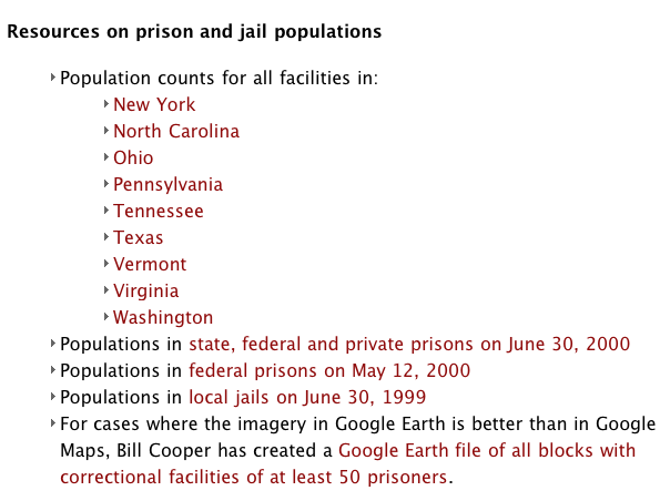
Screenshot showing links to resources available on prison and jails. Note that the list of states will match all states that produced results in your search. Here, nine states have a "Franklin County."
The identification process will require some detective work and the process of elimination. The population counts will not match exactly, partly because prison populations change from time to time and partly because of different Census Bureau or Bureau of Justice Statistics procedures. When we use this system, we consider it a match when the expected population is within 10% of the population reported in the Census.
You may find a number of small facilities with fewer than 50 people incarcerated that are not a part of any known state, federal or local prison. These are most likely halfway houses and can be safely ignored.
Here is a table that you may find helpful to use for notes:
| Block | Tract | Correctional Population | Facility Name | Type | District (leave blank until Section 3) | Notes |
|---|---|---|---|---|---|---|
At the end of this section, you will know how many census blocks in your county contain incarcerated people from outside your county, and you'll know where people are incarcerated in each of those blocks. The next section will combine this knowledge with individual county districts.
Recommended Reading:
About the Prison Policy Initiative
Learn more about the organization behind the Prison Gerrymandering Project.

The Racial Geography of Mass Incarceration
The transfer of Black and Latino incarcerated people to communities very different than their own is a nationwide problem.

How to get elected without being a candidate first.
Iowa Public Radio explores how Anamosa Iowa ended prison gerrymandering.
