- Sections
- Introduction
- Section 1: Getting started
- Section 2: Accessing Census data
- Section 3: Calculating the impact on districts
- Section 4: Repairing your democracy, now and in the future
- Tools
- Correctional Facility Locator (2020)
- Correctional Facility Locator (2010)
- Correctional Facility Locator (2000)
- Vote dilution calculator
- 2020 Worksheet [DOC] a single worksheet updated for use after the 2020 Census to determine if a county included or excluded the incarcerated population.
- Worksheets [DOC] with all of the tables used in this toolkit
- Appendices
- Handling lettered blocks
- Determining whether prisoners were included or excluded from districts with known populations.
- District population deviations & split prisons
- Weighted Voting
Appendix:
Handling lettered blocks in the Count Question Resolution Program
Users of the Correctional Facility Locator in the following counties:
- Chatham County, Georgia
- Boone County, Missouri
- Pike County, Missouri
- Caldwell County, North Carolina
- Davie County, North Carolina
- Johnston County, North Carolina
- Wilson County, North Carolina
- McCormick County, South Carolina
- Claiborne County, Tennessee
- Wise County, Texas
- Chittenden County, Vermont
may find that their county's Count Question Resolution Program data mentions blocks that are four digits with a letter, not just four digits. Typically, this happens because the Census Bureau's original block crossed into another town. Rather than create a new block, the Census Bureau split the block into pieces. Unfortunately, the new maps are not available on the internet, but we can show you a textual workaround.
These four screenshots will explain what to do, with McCormick County as an example.
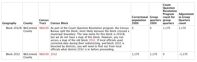
This screenshot shows that the prison placed in Block 2032 was actually in Block 2032B. (The group quarters population in Block 2032 was published at 1,170, and corrected at 0, so it must be somewhere else. The only other block with a similar correction number but in the opposite direction is Block 2032B.)
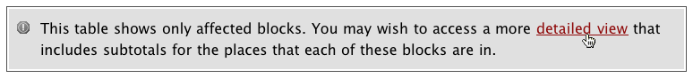
But where is Block 2032B? We know it is a portion of Block 2032, but we need more information. This option at the bottom of the Count Question Resolution program screen shows a more detailed view of how the population changed in units larger than blocks, including tracts, county subdivisions and places:
The detailed view will look like this:
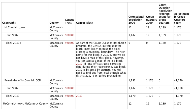
The table shows that the Census drew the original Block 2032 entirely within the McCormick CCD. (CCD's, or Census County Divisions, are statistical divisions created and named by the Bureau. In most states they do not match local government boundaries, and should not be confused with formal government bodies.) The table also shows that, Block 2032B is within McCormick Town. So Block 2032B is a portion of the old Block 2032 that happens to be in McCormick Town.
So how would you use this information in Section 3? If a district boundary happens to follow the northern boundary of McCormick Town and the legislature used corrected data, then the prison is in the district that includes McCormick town.
Recommended Reading:
About the Prison Policy Initiative
Learn more about the organization behind the Prison Gerrymandering Project.

In prisons, Blacks and Latinos do the time while Whites get the jobs
We explore the racial disparity inside prisons.

Rome NY ends prison gerrymandering, Census Bureau can do better
Rome finally corrected the problem of prison gerrymandering within its borders; other cities and counties need the Census Bureau's help.

Prison-based gerrymandering's historical precedent
This is not the first time a policy barred people of color from the polls and transferred their political power to white voters.